Flores is the westernmost island of the Azores, of Portugal, and of Europe. The name (which means flowers) was given by Portuguese settlers in the 16th century for the dense wildflowers that covered the cliffs. The reality matches the romance: tall basalt cliffs dropping vertically into the ocean, waterfalls cascading from the central plateau down to the coast, seven crater lakes scattered across the high interior, and the smallest population per square kilometre of any Azorean island.
Flores is the most distant of the inhabited Azorean islands. From Lisbon the flight is 2 hours 45, from São Miguel another 90 minutes, from any North American city a minimum of two connections. The isolation is structural: Flores sits on the North American tectonic plate (the rest of the central group is on the Eurasian) and 240 kilometres of open Atlantic separate it from the nearest neighbour.
The reward for the journey is the most dramatic landscape in the archipelago. Waterfalls drop 300 metres in a single fall. Crater lakes sit on the central plateau under perpetual cloud. The cliffs on the west coast are the tallest in the Azores. Flores is the photography island.
This guide covers what to expect, when to come, the waterfalls and lakes, and how to plan a stay of 3 to 5 days.
Why Flores
Flores is the right pick for travellers who want raw Atlantic landscape, dramatic photography, and genuine isolation. The population is around 3,500. There are 2 small towns, 6 villages, and a single ring road. You can drive every public road on the island in a long afternoon.
It is the wrong pick for travellers who want concentrated tourist infrastructure, restaurant variety, or beach time. Several restaurants close at 9pm, the choice of accommodation is narrow, and the weather is the wettest of the archipelago.
Flores combines well with Corvo (the smaller sister island 17 km across the channel) as a 4-to-6 day western-group trip. It does not combine easily with the central group due to flight frequency.
Geography and climate
Flores is 17 km long and 12 km wide, oriented roughly north-south. The interior is a high plateau at 500 to 900 metres altitude, with the seven named lakes scattered in a cluster on the central section. Morro Alto is the highest peak at 914 m. The east coast is gentler; the west coast is dramatic with the tallest cliffs in the archipelago.
Santa Cruz das Flores on the north-east is the capital, with the airport. Lajes das Flores on the south coast is the second town and the ferry port to Corvo. The other villages (Fajã Grande, Mosteiro, Fazenda) are scattered around the western and southern coasts.
The climate is the wettest of the archipelago (around 50% more rainfall than São Miguel). The central plateau is in cloud on most days. The cliffs of the west coast catch the prevailing Atlantic fronts; the east is comparatively sheltered.
Top experiences on Flores
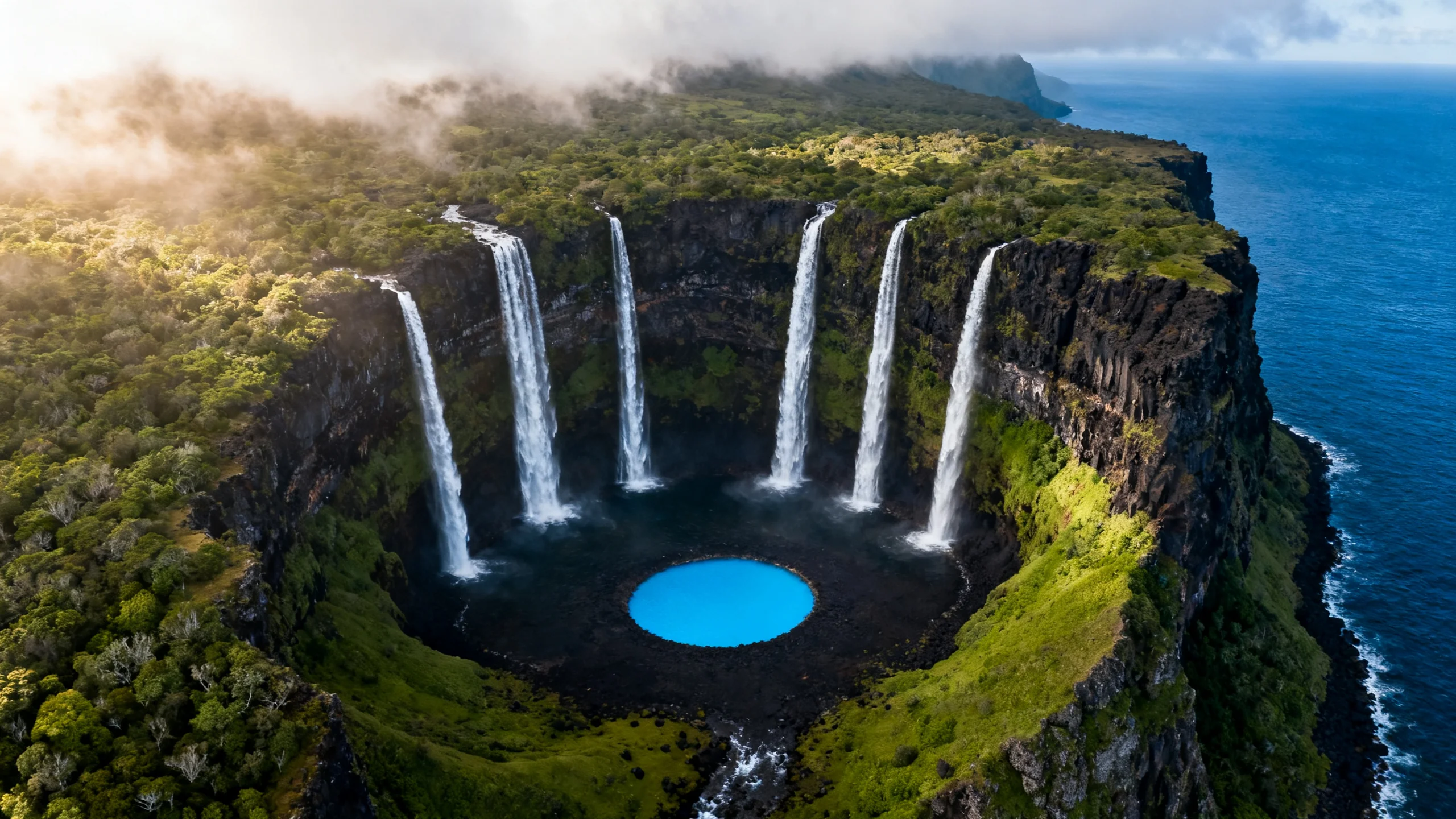
Poço da Alagoinha. Six tall waterfalls cascading from the surrounding volcanic cliffs into a single circular basin, with a small lagoon at the centre. The most photographed landscape on Flores. Reached via a 20-minute walk from the EN1 viewpoint at Ribeira do Ferreiro. See the waterfalls of Flores guide for the detail.
The seven lakes. The central plateau holds seven named crater lakes within a 4-kilometre stretch: Lagoa Funda, Lagoa Comprida, Lagoa Branca, Lagoa Negra, Lagoa Rasa, Lagoa das Patas, Lagoa Lomba. All are visible from the central trail (PR 1 FLO) at 600 m altitude. Best in spring (April to June) when the lakes are at their fullest. Allow a full day for the lake-loop walk.
Rocha dos Bordões. A natural formation of vertical basalt columns 30 metres tall, the result of slow cooling of a thick basalt lava flow. The columns line the cliff face like organ pipes. Located on the west coast, 15 minutes’ drive from Lajes. Free, no fence, photographic at sunset.
Fajã Grande village and beach. A small village on the south-west coast with a black-pebble beach, a small swimming pool, and access to the Ponta da Caveira lighthouse trail. The westernmost settlement of Europe.
Cliffs at Ponta do Albernaz. The westernmost point of Europe, a 200-metre cliff falling vertically into the Atlantic. Access via the EN3 road to Cedros village, then a 1-kilometre trail. The North American tectonic plate begins underwater here.
Trans-island hike (PR 1 FLO). The 16-kilometre central traverse crosses the seven-lakes plateau and connects the east coast to the west coast. Allow 6 to 8 hours. The most strenuous walk on Flores but the broadest landscape sample.
Where to base yourself
Santa Cruz das Flores is the practical default. The airport, most accommodation, the only proper restaurant scene, and the small museum. Drive times from Santa Cruz: 25 minutes to the central plateau, 35 minutes to Poço da Alagoinha, 45 minutes to Fajã Grande, 30 minutes to Lajes.
Lajes das Flores on the south coast is the alternative for travellers who want quieter and closer to the Corvo ferry. Less restaurant choice; some travellers do Day 1 from Lajes and Day 2 from Santa Cruz.
The dedicated where to stay on Flores guide breaks down the choice.
Getting to Flores
Flores Airport (FLW) is small. Direct service is limited:
- São Miguel (PDL): SATA, 4 to 6 weekly, 90 minutes.
- Terceira (TER): SATA, 2 to 4 weekly, 90 minutes.
- Lisbon (LIS): TAP, 3 weekly summer charters only.
There is no direct international service. The standard routing is via PDL: fly into São Miguel, then 90-minute SATA inter-island to FLW. The flight is on a Bombardier Q400 turboprop; weather cancellations happen 5 to 10% of trips in winter.
A small Atlanticoline ferry runs from Lajes das Flores to Corvo, 30 minutes, several daily in summer, €15 one way. There is no ferry to the central group; Flores is reached only by air for the rest of the archipelago.
See how to get to Flores for the detailed connection options.
Getting around
A rental car is essential. The ring road is 75 kilometres including the spur to Ponta do Albernaz, drivable in 2 hours without stops. The interior plateau roads are narrow but paved. No reliable bus network.
Companies: Ilha Verde and a small local operator at the airport, €35 to €75 per day. The fleet is genuinely small; reserve well in advance for July to August.
Suggested itineraries
3 days, focused. Day 1: arrival, Santa Cruz town walk, drive through the central plateau, sunset at Rocha dos Bordões. Day 2: Poço da Alagoinha morning, drive the west coast, lunch at Fajã Grande, afternoon at Ponta do Albernaz. Day 3: the seven-lakes walk on the central plateau.
5 days, comprehensive. Days 1 to 3 as above. Day 4: Lajes das Flores morning, ferry to Corvo for a day trip, return same evening. Day 5: the trans-island PR 1 FLO hike or a slow rural drive through the southern villages.
Best time to visit
- May to June: the best month. Waterfalls at full flow, hydrangeas starting, the central plateau visible on most clear days. The window most photographers choose.
- July to August: peak summer, warmest sea, ferry to Corvo at full schedule. Waterfalls reduced compared to spring.
- September to October: quieter, water still warm enough to swim at Fajã Grande, the autumn light is particularly good for photography.
- November to April: off-season. The cloud sits on the central plateau for weeks at a time, accommodation choice narrows, and the SATA flights cancel more frequently. Worth visiting only for travellers who genuinely want the dramatic Atlantic storms.
Frequently asked questions
Is Flores worth the long flight?
For travellers who care about dramatic landscape and have 4 to 5 days, yes. The Flores landscape is qualitatively different from the rest of the Azores: more vertical, more raw, more remote. First-time Azorean travellers may prefer to stay in the central group; second-time visitors who already know São Miguel and Pico typically rate Flores as their favourite.
How does Flores compare to Madeira?
Both are volcanic islands with dramatic landscapes, but the texture differs. Madeira is more tropical (warmer, palm trees, banana plantations) and more developed for tourism. Flores is cooler, more austere, much smaller, and far less visited. The waterfalls on Flores are taller and more pristine than the Madeiran equivalents, but the Madeiran hiking infrastructure is more extensive.
Is the weather really that bad?
Wetter than the rest of the Azores, but rarely all-day washouts. The pattern is fast-moving rain bands and clear windows; you adapt your day to the sky rather than the forecast. The central plateau spends most of the year in cloud, so the lakes are often not visible from a distance even on otherwise sunny days. Build a buffer day or two into your itinerary.
Can I do Flores in 2 days?
Technically yes, but the round-trip flight effort is hard to justify for under 3 days. The minimum that makes the journey worthwhile is 3 full days on the island plus arrival and departure travel time, so 3 nights minimum. If you only have 2 nights, consider Pico instead.
Why is Flores on the North American plate?
The Mid-Atlantic Ridge, the spreading boundary between the North American and Eurasian plates, runs through the Azores between Flores-Corvo (on the North American plate) and the rest of the islands (on the Eurasian plate). Flores and Corvo are technically part of North America in tectonic terms, while geographically and politically they are part of Europe. The closest land on the North American side is Newfoundland, 2,200 kilometres away.