Lagoa do Fogo
"Lake of Fire", the youngest crater lake on São Miguel, sitting at 575 m inside the Água de Pau massif. The view from the rim is one of the most striking on the island, and the descent to the lake shore is the rare Azorean trail that ends at a place no road can reach. Here is what you need to know.
What Lagoa do Fogo is
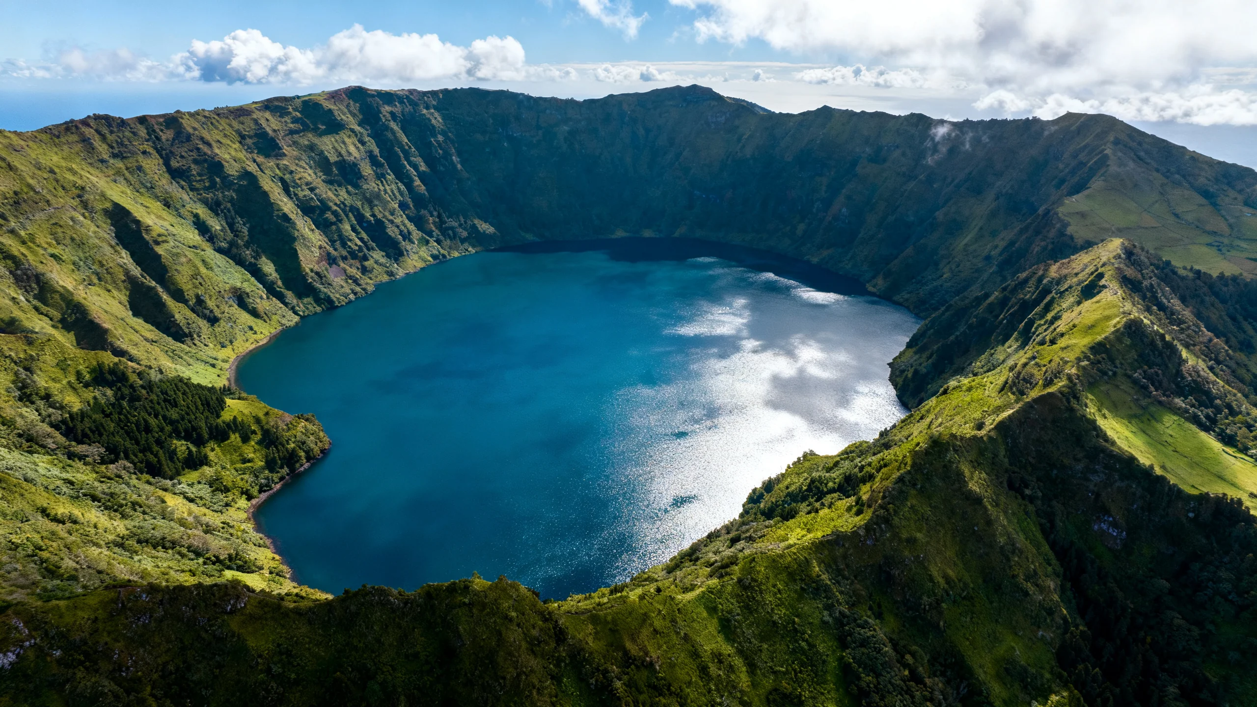
Lagoa do Fogo fills the inner caldera of the Água de Pau volcano, the central of São Miguel's three volcanic massifs. The last eruption was in 1563, by Azorean standards, recent, and the lake formed inside the resulting caldera. The water is mineral-poor, cold, and exceptionally clear; the lake is a designated nature reserve, with no buildings, no road access to the shore, and regulated visitor numbers.
Setting aside Sete Cidades (which is more dramatic to look at from above), Lagoa do Fogo is the most "wild" of the major crater lakes on the island. The first thing visitors comment on is the silence, the protected status keeps the surroundings undeveloped, and the caldera walls cut off the sound of traffic on the ER1-1A road that skirts the rim.
The view from the rim
Two main viewpoints, both on the southern rim and reachable by car:
Miradouro da Lagoa do Fogo (southern lookout). A small paved lookout off the ER1-1A road, with parking for around 20 cars. The view is the standard postcard angle, looking down into the caldera from the south. The lookout is exposed and can be windy.
Miradouro do Pico da Barrosa. A more elevated lookout slightly to the east, with a telecommunications tower at the top. The view is wider, you can see Lagoa do Fogo in one direction and the south coast of the island in the other. Smaller parking, less popular.
Both viewpoints sit at around 800 m elevation and are frequently in cloud. The first half-hour of clear weather after a fog lifts is often the most rewarding, as the lake reflects whatever sky is above.
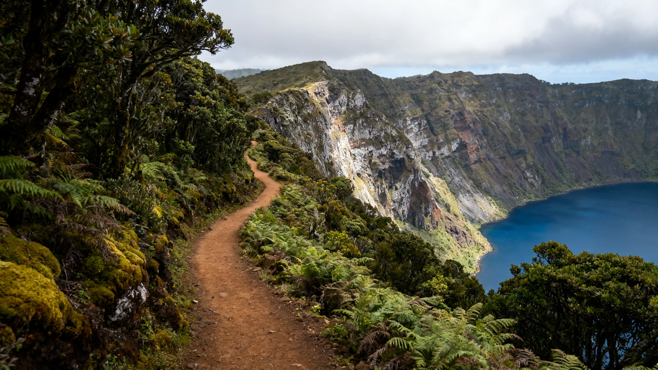
The descent to the lake
The official trail (signposted "PRC02 SMI") descends from a small roadside trailhead about 1 km east of the main lookout. The walk down takes around 45 minutes, with switchbacks on a packed-dirt path. The climb back up takes around an hour. Total return walk is about 4.7 km.
The path is well-marked but unmaintained in parts, expect tree roots, occasional muddy sections after rain, and one or two scrambly bits near the bottom. Hiking boots strongly recommended; trainers will get you down but might struggle on the way back if the path is wet.
At the lake shore, you arrive at a small black-sand beach at the north end of the lake. There are no facilities, no buildings, no toilets, no café. Most visitors swim (officially discouraged but widely done), have a packed lunch on the sand, and head back up.
Swimming
Lagoa do Fogo's water comes from rain and groundwater only, with no thermal input. Surface temperature averages around 18 °C in summer, cold but possible, especially in calm sun. The shore drops off quickly, so once you are a few metres in, the water is deep.
Swimming is technically restricted because the lake is part of a nature reserve, but enforcement is minimal and locals swim routinely. The compromise approach: enter only at the official trailhead-end beach, do not bring food into the lake, and do not leave litter. The lake's clarity is part of what makes it spectacular, and visitor behaviour determines whether that lasts.
Photography
Best light: mid-morning to early afternoon for the rim viewpoints, when the sun catches the water from above and the lake reads its full blue. Sunrise from the rim is dramatic but the lake is in shadow.
Fog handling: if you arrive in cloud, stay 15–20 minutes. Lagoa do Fogo fog often lifts in a single sudden moment, revealing the lake against a still-cloudy sky for a few minutes before the cloud closes again. Many of the best photos come from this transition.
From below: the view from the lakeshore looking up at the caldera walls is the less-photographed angle and arguably more striking than the rim view. The 45-minute descent is the price of admission.
Getting there
By rental car: 35 minutes from Ponta Delgada via the ER1-1A. The lookouts and the trailhead all have road-level parking; no off-road driving needed. From Ribeira Grande, 20 minutes. From Furnas, 50 minutes.
Without a car: the only realistic option is a guided tour combining Lagoa do Fogo with another sight. The most common pattern is the Sete Cidades and Lagoa do Fogo tour with lunch, a one-day tour from Ponta Delgada covering both crater lakes, with a 30-minute stop at the Lagoa do Fogo lookout. For a longer version that includes time at both Sete Cidades and Lagoa do Fogo with lunch built in, the full-day Sete Cidades and Lagoa do Fogo tour is the alternative.
Most group tours visit only the rim viewpoint; very few include the descent. If walking to the lake itself is important to you, plan with a rental car.
Caldeira Velha (combine on the way back
About 10 minutes by car downhill from the southern lookout, on the road toward Ribeira Grande, sits Caldeira Velha) a small forest thermal complex with a warm waterfall, a heated pool, and shaded picnic areas. Entry around €8, capacity capped at about 30 people, often busy in summer.
The natural pairing is: Lagoa do Fogo hike in the morning, Caldeira Velha for a thermal soak in the afternoon. The combination works well as a half-day with a rental car. Bring dark swimwear. Caldeira Velha's water is iron-rich and stains.
Weather strategy
Lagoa do Fogo is the most weather-sensitive of São Miguel's landmarks. The rim sits in cloud roughly half the time year-round. Two practical tips:
- Check the live webcam before driving up. The
regional tourist board operates one at the southern lookout,
accessible from
visitazores.com. - Plan a backup. If you arrive in fog, drop down to Caldeira Velha and the north coast (Praia dos Moinhos, Gorreana tea), and come back to the rim later in the day or the next morning. Cloud at altitude is independent of weather at sea level.
FAQ
How much time do I need at Lagoa do Fogo?
Rim viewpoint only: 30 minutes including walking from the parking. With the descent to the lakeshore: 3 hours.
Is the descent too difficult for non-hikers?
It is not technical, no scrambling, no exposure. But it is steep, unmaintained, and 200 m of elevation each way. If you are not regularly active or you do not have proper footwear, skip the descent and stick to the rim views.
Can I drive down to the shore?
No. There is no road into the caldera. The trail is the only legal access to the shore.